Zoom into Green Canyon
Green Canyon and First Creek drain a watershed in Kittitas County, Washington
State, USA. Here is a relief map of the county
with the watershed outlined in red. The green lines define the boundaries
of the four 7 1/2 minute USGS quads listed in the bibliography. The city
of Ellensburg is just south of the lower green line, on the aluvial fan.
In case you lose your place in the story, here's some helpful links and
a sneak preview of topics: how the location determines the climate,
how water has changed it over the years, all about
the fascinating geology, the soils
and topography, the vegetation, and some facts about
the animal life. There's some cultural history
too, and even a bibliography.
The Story
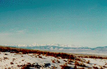
Summer solstice, northern hemisphere, northwestern
corner of the United States: the morning sun peeps into Green Canyon, nestled
into the hills north of the Kittitas Valley.
Because the region lies in the continental rain shadow of the Cascade Range,
the climate here is semi-arid and the day will likely be hot and sunny.
Since Green Canyon lies at latitude 47o 12' North, the sun will stay in
the southern sky, at a maximum angle of 66 ½ degrees from the horizon.
At the winter solstice, six months away, the noon sun will be received
at only 19 ½ degrees from the horizon. There will be snow in the
hills and probably on the plain as well.
In spring that snow will melt and run downslope into
folds and ravines, cutting them ever deeper. Above Green Canyon in the
First Creek watershed, ice that formed under the talus will melt more slowly,
producing freezing cold springs even in the summer. Seeps occur in several
places, where underground layers of permeable and impermeable rocks absorb
water and slow its downward percolation. When a cross section of layers
is exposed, water seeps out of the permeable interbeds. All of this water
is an essential force behind the shape of the watershed.
Long ago First Creek was a small tributary of Swauk Creek, which probably
flowed through Horse Canyon on its way to the Yakima River. At that time
a tributary of Dry Creek was wearing slowly through the basalt in Green
Canyon, though not in the current streambed. First Creek cut back into
the hills so deeply that it intercepted the tributary, and the water all
flowed down the First Creek draw, leaving Green Canyon literally high and
dry.
Thousands of years later two men named Wold and Munson collaborated to
built a ditch which diverted water from First Creek
down Green Canyon again. Wold started the ditch in 1881 to supply irrigation
water to his land ten miles below the mouth of Green Canyon, a vicinity
still known as Woldale. Perhaps he got the idea from the Oak Bar mining
claim he purchased the year before. Munson had developed Oak Bar on the
Yakima River at the mouth of the Swauk, diverting First Creek for his use
by means of a dam and a mile-long ditch in 1877 according to the contemporary
custom: whoever wanted water "took and appropriated the same subject
only to the rights of prior appropriators." He also surveyed a route
from the same diversion point that would provide irrigation water in case
he bought land in the valley below Green Canyon, which he later did buy.
Wold sold an undivided half interest in his ditch to Munson, who helped
him expand the system according to his prior survey until the ditch was
five feet wide at the base, seven feet wide at the top, two and one quarter
feet deep, with a fall of one quarter inch per rod in 1886. Such exact
records probably would not exist if the farmer who owned the land on the
prairie at the mouth of First Creek had not broken up their dam in 1891
and re-appropriated the water. This led to a fairly drawn-out court battle
which Wold and Munson finally won in 1899, when the defendant reluctantly
anted up two bales of hay to pay for the damages.
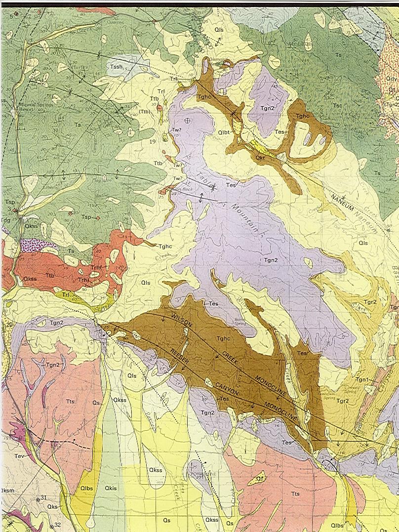
Here's the pertinent section of the USGS Wenatchee
Geologic Quadrangle!
Why was First Creek able to cut so far into the hills above it and "steal"
the Dry Creek tributary in the first place? The answer lies in the area's
geology. On the map, cream colored "Qls" underlies First Creek's
natural drainage. Qls is poorly sorted, undifferentiated landslide deposited
material. In this area, three very different basalt flows meet a segment
of the Roslyn Formation, the same sandstone and shale beds that contain
the Roslyn coal fields. Erosion occurred at different rates in different
materials, causing slumping, undercutting and landslides. The steady influence
of water did the rest.
First Creek has a coal seam of its own where the Roslyn Formation ("Trl")
is exposed. In the late 1800s the First Creek Coal Company was formed to
mine this seam, but the company apparently vanished without mining anything.
The coal was formed when the predecessor to the Cascade Range was only
a low elevation barrier between the Pacific and enormous inland lakes.
The mild, wet climate that existed here before the Cascade uplift promoted
such rapid organic sedimentation in these shallow lakes that complete decomposition
was impossible. By forty million years ago the organic material had settled,
compressed and lithified into coal. On the other hand, the landslide action
is (geologically speaking) quite recent, only occurring within the last
two million years.
The red "Ttb" north of First Creek forms part of the watershed
boundary. This is Teanaway basalt, laid down as much as fifty million years
ago. This basalt is of special interest because the famed Ellensburg blue
agates were formed in it. Cavities in the hardened lava were slowly filled
by siliceous minerals as cold water percolated through. Solutions changed
composition over time, leaving bands of varying tints. Some cavities did
not fill completely and formed geodes instead of solid agates. The color
of the agate developed from the particular minerals in solution. Shades
from brilliant cobalt blue to pale sky blue are found, along with green,
gray, taupe, and white agate.
The purple "Tgn2" that forms Table Mountain and the ridges west
and southeast of Green Canyon is part of the Columbia River basalt flows.
These flows occurred over a lengthy period of time, stopping a mere twelve
million years ago. The brown "Tghc" of the Wilson Creek and Reecer
Canyon monoclines is also part of the same flow sequence, but the polarity
in this flow is reversed. When this particular basalt was oozing from the
earth about twenty million years ago, the earth's polarity was the opposite
of what it is now.
Another zone of interest from the geological map occurs at the mouth of
First Creek. This unlabeled pale yellow zone is sidestream alluvium. It
runs north up Swauk Creek and branches into Williams Creek. A 1897 map
of placer gold claims overlays this zone nearly perfectly.
Even though most of the gold was tantalizingly over the ridge from First
Creek and Green Canyon, their geomorphology combined to let them be part
of gold rush history. In 1873, a 20-year-old range rider named Bill Taylor
was roofing the Smith Ranch cookhouse when Fint McDonald thundered by and
told of the gold discovery on the Swauk. Bill saddled up and rode as quickly
as he could "through Green canyon and down First creek" to stake
a claim for himself. During the gold boom, many people may have taken this
route to get to the gold camps and the parties: nightlife centered around
Liberty and Meaghersville in those days. Ellensburg
was just the quiet little supply center for that thriving place.
One of the less flashy but more lastingly influential
products of the climate / geology interaction is soil. The parent material
for the soil in this watershed is largely basalt. Basalt weathers into
fine clay particles. A walk through Green Canyon after the autumn rains
begin is a splendid introduction to the sticky, clump-forming nature of
basalt clays. First Creek soils have more sand particles from breakdown
of the exposed Roslyn Formation sandstones. This soil is much less sticky
when wet. The color of the soil is also an indicator of parent material.
Red indicates Teanaway basalt, black indicates Columbia basalt, and light
colors come from the sandstones.
Elevation in this watershed varies from 2,240 feet at the mouth of First
Creek and 3,000 feet at the mouth of Green Canyon to 6,040 feet at the
uppermost boundary near Lion Rock. Slopes can be steep, as suggested by
this gradient. Soils are thin on steep slopes because gravity continually
pulls particles down slope. Thicker soils will accumulate on gentler slopes
and ravine bottoms, and will support different and lusher vegetation. Aspect,
the direction which a slope faces, is another critical factor for vegetation.
A south aspect ensures lots of sun because the sun is always in the southern
sky at this latitude. This ensures a drier summer, more extreme freeze
/ thaw cycles, patchier vegetation, and forests that are more open. A north
aspect ensures moisture retention and lower temperatures, because it is
protected from the sun. This allows thicker vegetation, denser forests,
and gentler slopes due to less frost erosion. North aspects may get no
sun at all by winter solstice.
Elevation has yet another effect. Moving up in elevation has the same effect
as moving poleward in latitude: the air is colder and therefore must precipitate
excess moisture as it rises and cools, summer is shorter, and winter is
longer. On the east side of the Cascades the subalpine zone (the highest
at which trees can grow ) starts at about 5000 feet. At the other extreme,
arid steppe is found at about 2000 feet in the Kittitas Valley. Because
this entire range is found in the watershed, every one of the east-side
biomes is represented in a wonderfully complex mosaic.
Sagebrush steppe sweeps up the ridges where summer drought
and south-facing slopes combine to produce near-desert conditions. Open
forests of stately ponderosa pine dominate low elevations, especially on
south-facing slopes, where frequent surface fires formerly kept out competing
vegetation. Douglas-fir and grand fir clothe the north-facing slopes and
protected swales, gradually infiltrating the pines in the absence of fire.
Subalpine fir, Sitka spruce and lodgepole pine are tucked into high ravines
where the snowpack stays longest and the cold season may last six months
or more. Lower riparian zones support giant cottonwoods and aspen groves.
Each of these ecosystems relies on a subtle combination of factors including
elevation, aspect, slope, and soil to provide another set of factors including
temperature, sunlight, and moisture for their optimum growth. Each ecosystem,
adapted to one of these unique niches, in turn provides unique habitat
for the animals of the region.
Before the advent of the Europeans, mule deer and
Pacific black-tail deer were common here. Elk and bighorn sheep were abundant,
as were many smaller animals important to humans for food and clothing.
In 1824 Governor Simpson of the British Hudson Bay Company issued a decree
for his trappers to "scour the land"and kill all the game from
Fort George on the coast to Fort Okanogan, in order to discourage American
settlement from the east. By the turn of the century the elk and bighorn
sheep were gone, and there were very few deer or smaller mammals. Incidentally,
the Colockum elk herd that migrates through the watershed in spring and
fall, now over six thousand strong, all descended from 45 elk shipped from
Montana in 1915.
Simpson's decree did much more damage to the local
inhabitants than to the prospective American settlers. A branch of the
Yakama nation was inhabiting the Kittitas Valley when the Europeans arrived.
The valley was also a gathering ground for many different tribes. Alexander
Ross, a trapper and probably the first European to set foot in the Kittitas
Valley, wrote in 1814:
...at that place all the Indians were rich in horses. The Cayouses, the
Nez Perces, and other warlike tribes, assemble every spring in the Eyakemas
[Kittitas Valley] to lay in a stock of the favourite Kamass and Pelua,
or sweet potatoes, held in high estimation as articles of food among the
natives. There also the Indians hold their councils, and settle their affairs
of peace or war for the year; it is, therefore, the great national rendezvous,
where thousands meet, and on such occasions, horses can be got in almost
any number; but, owing to the vast concourse of mixed tribes, there is
always more or less risk attending the undertaking.
This central council and gathering ground was called Che-loh-an, and was
nine or ten miles east of present-day Ellensburg near Caribou Creek. By
1841 the natives had virtually nothing but salmon and camas to eat, in
an area where food had been tremendously varied and abundant.
Perhaps that is why cattle were brought in by the native people in 1840.
After central Washington was opened to American settlement by the Walla
Walla Council treaties in 1855, the settlers brought more cattle. Horses
had been plentiful since the 1700s or before, so the Valley had been under
grazing pressure for quite a long time.
Sheep arrived in the 1870s and proved to be a critical overload: overgrazing
was a severe problem only ten years later. Sheepmen were complaining about
overstocking in 1902. In 1903 George Otis Smith wrote: "This industry
has seriously injured the region. Desolate tracts of burnt timber and rocky
slopes, where sharp hooves have cut up the turf, allowing the soil to be
washed away, mark the track of the sheep herder." Sheep allotments
were set up in 1905. Cattle allotments followed in 1907. The Forest Service
estimates that sheep use peaked in 1916 with at least 45,000 ewes traveling
on the First Creek driveway (current maps call this the Teanaway-Wilson
driveway) plus another 6000 on the Naneum-Wilson Driveway. Use of the driveways
continued into the 1950s but in decreasing numbers. The big stock drives
were over in the 1930s.
The indigenes used Green Canyon and First Creek for hunting and for vision
quests. Ambush pits (a hunting blind made from excavating a pit in deep
talus scree above a game trail) and stone quarry sites have been found
in the doug fir zone. Food storage pits, more hunting blinds, chipped stone
tools, campsites and vision quest rock cairns have been found in the subalpine
zone.
The settlers were more interested in using the timber itself. Homesteaders
selected straight, healthy trees for houses, outbuildings, and split-rail
fences. Budding towns like Ellensburg needed timber for their boardwalks.
Miners took timber to shore up their hard-rock or quartz mines as they
tunneled underground in pursuit of gold. Every home and business required
firewood. In 1908 the government surveyed the remaining timber resources
in the area. They found that the First Creek watershed had mostly limby,
scruffy timber and that much of it had been severely burned. This stand-replacing
fire evidently happened in the 1800s but the precise date is unknown.
In the 1930s The Cascade Lumber Company surveyed the Swauk Creek watershed,
including First Creek, preparatory to moving operations from the Teanaway
watershed. They originally planned to run a rail line near Wold's ditch
from Woldale up Dry Creek toward the hills for delivery of the logs to
the Northern Pacific line, but advances in trucking equipment and road
development made them turn to trucking instead. A rail line was still the
best way to get machinery and men to the work sites and to move the logs
out of the hills, however. The main headquarters for the Swauk operation
was on the flats above the mouth of First Creek. Bunk and cookhouse cars
were parked on a spur, while the offices, outbuildings and a few houses
lined the tracks downstream from the water tower, coal bunker and train
shed. The tracks ran about two and a half miles up First Creek to Camp
1, where another railcar community was located. Camp 2 was further yet
up the creek. Both of these logging camps were developed in 1931 and abandoned
by 1944.
The current landscape reflects the ongoing interaction between humans and
nature. Green Canyon hosts an enclave of summer cabins and hunting hideaways.
Most of lower First Creek is owned by Boise Cascade, a legacy from the
Cascade Logging Company. Part of the watershed is administered by the Forest
Service. Some of the land is fenced for an active grazing permit. There
are mines for semiprecious blue agate and precious gold. In fall a number
of hunters will arrive to pursue grouse, deer and elk. They, like many
others, also come to revel in the fascinating
mix of natural and cultural history that is the Green Canyon / First Creek
watershed.
Written by Kylea Kirsch - 1996